Understanding the seasonal climate transitions
The seasonal climate transitions (in winter, spring, summer and fall) at northern latitudes give remarkable insight into climate feedback processes and the coupling of the water cycle to vegetation.
The perceptive observer can relate their experience of the seasons to key climate change processes, such as water vapor feedback and snow-ice albedo feedback; and understand the distinct roles of the three phases of water (ice, liquid and vapor) in the surface energy balance. The illustrations will be taken from Vermont in northern New England, but the discussion is relevant wherever there is a winter cold season with temperatures well below freezing. These seasonal climate transitions are sometimes obscured by the rapid changes of weather from week to week, but most years they are visible. Despite this, the underlying climate processes are generally not well understood, even by many atmospheric scientists and weather forecasters.
The Seasonal Transitions
The seasonal variation of water vapor with its large greenhouse effect, the seasonal variation of snow with its large reflectivity and the seasonal variation in vegetation (which affects transpiration) drive important transitions in seasonal climate in mid-latitudes. The effect of these climate processes involving water can be seen locally.
Winter transition
We will start with the sharp transition into winter that often occurs with heavy snowfall. As the sun at noon drops lower in the sky in fall (at our latitude of 44oN) and we approach the winter solstice, the days get shorter and the nights longer. Mean temperature falls because the earth cools more to space at night than it is warmed by the sun during daytime. If the sky is clear and dry, more of the sun’s energy reaches the earth (less is reflected by clouds), but the earth also cools more to space at night.
The first heavy blanket of snow however plunges us from fall into winter, because it reflects a lot of the sun’s energy. Fresh snow on a grass field may reflect 80% of the sun’s energy, although this falls to 50-60% as the snow ages. A recent paper shows that an agricultural region covered with winter snow reflects 70% of the sunlight, and this causes a drop of temperature of 18F. In contrast, a dense forest may reflect only 20-30% of the sunlight, because the trees shade the snow and absorb the sunlight themselves. (See Figure .) Because the snow reflects much of the sun’s energy, the temperature stays below freezing and the snow remains, slowly becoming more crystalline and icy.
There is a second process involved that is less obvious. The reflection of sunlight means there is less energy available for evaporation – actually the sublimation of snow. The saturation vapor pressure is also lower over ice than over water, and this also reduces sublimation of snow. The reduced input of water vapor at the surface gives a still drier atmosphere. This dry atmosphere reduces the water vapor greenhouse effect, which means the downward longwave flux is reduced. This in turn means the earth can cool more strongly in the infrared. The net result is that a blanket of snow drops the mean temperature sharply by two processes: greater reflection reduces the net shortwave heating, while the net longwave cooling increases, because the water vapor greenhouse is reduced.
Spring transitions
The spring transition from March to May in Vermont is always extraordinary. It has two distinct stages. In winter the ground is frozen with a large ice content. As the sun rises higher in the sky through the spring equinox, it first takes a lot of the sun’s energy to melt the ice in the ground (and any lingering snow patches). Until this happens, the soil remains cold at freezing and water is not available for plants to grow. (This process is seen earliest in sugar maples as the sap starts rising when temperatures rise above freezing during the daytime.)
Once the ground has thawed and dried a little, gardeners can start to turn over winter cover crops. Often a week or two of warm dry weather follows, as the sun, returning to the north, climbs higher at noon in the sky. Sometimes in April, sunscreen is needed to work outside with the noonday sun burning in a clear, blue sky. These warm spells after the ground melts and before leaf-out, are typical of northern spring climate.
Figure 2 shows a typical day during this period. (See Figure .) When there are no leaves on the trees, there is little evaporation, which takes up a lot of the sun’s energy, so it can get hot. With little evaporation, the atmosphere stays dry. With little water vapor and clouds in the air, the days are hot, and the nights cool, because the earth can cool quickly to space through the clear dry air (water vapor greenhouse is weak). Even though it is hot in the daytime, the daily temperature range between maximum and minimum is large and frosts are likely at night. But it gets so warm that in a few weeks, shrubs and trees quickly leaf out, and there is a second stage to the spring transition. Leaves take in carbon dioxide to grow, and they pump huge amounts of water vapor into the atmosphere. This process, called transpiration, moistens the air and cools the forests (much as we cool ourselves by sweating). Evaporation from soil and transpiration from vegetation are together called evapotranspiration, but for brevity we will use say evaporation.
On average, afternoon temperatures drop more than 3degC (5degF) as the leaves come out (Schwartz and Karl, 1990). Figure 3 shows a typical day after leaf-out of the forests. With all the evaporation, the air becomes more humid, so that clouds can form. (See Figure .) Clouds reflect some sunlight, and this cools the earth also. Afternoon showers are again possible, and passing fronts get more vigorous. The daily temperature range drops, because the earth cools more slowly at night with so much water vapor, a GHG, in the air. So after the trees leaf out, frosts become much less frequent. Vegetation, evaporation, the water vapor greenhouse and the local climate are linked together.
These spring climate transitions last about a month. Superimposed on them are the weather patterns, the succession of cyclonic storms or thunderstorms and high pressure patterns that typically pass every week in mid-latitudes. The passage of a ridge of high pressure gives a clear sky, which will accentuate the warm dry phase of the spring transition; while passing fronts will give cool wet days.
Summer transition
In spring the soil is usually quite moist, as it starts saturated after snow and soil-ice melt. The balance between precipitation and evaporation determines whether the soil dries down. Forests have roots that can draw on deeper soil water, so in spring there is enough water for transpiration and growth. If there is plenty of rain as well, the soil never dries down. In fact there is a positive feedback: wet soils give more evaporation and a lower cloud-base, which give heavier rainfall. Falling rain wets the leaves, and this water evaporated quickly back into the air, condensing to give more clouds and rain. (See Figure .) In several recent years this has been the pattern in Vermont, giving a cool cloudy summer with above average precipitation. Essentially spring weather continues into summer.
The summer transition occurs if evaporation exceeds precipitation and the soil dries down. This is common in most years in the plains states of the central US. As the soil dries down, evaporation falls, there are fewer clouds with higher cloud-bases and precipitation falls. So again there is a positive feedback, which gives warmer drier summer weather. It is warmer and drier because it is evaporation that cools the surface and moistens the air. This is the kind of weather that farmers need to harvest hay. (See Figure .)
In summer it is the availability of water that determines climate, because the evaporation of water takes up so much of the sun’s energy, buffering temperature rises. But although local processes have a big influence, synoptic weather patterns and global weather patterns all strongly influence local weather and climate. So this local evaporation-precipitation feedback can tip the balance in either direction. In several recent summers, New England has seen extended periods of heavy rain leading to flooding. However if global weather patterns impose an period of high pressure over New England (in which sinking air suppresses clouds and rain, so that the soil dries down) then this feedback can lead to extended periods of summer drought. If dieback of vegetation results, then this reduces further evaporation, prolonging the drought. Sometimes a powerful event is needed to break a summer drought, such as when the remains of a tropical storm or hurricane move up over New England dumping a lot of rain.
Fall transition
The fall transition that occurs with the first hard frost illustrates again how life, water and climate are linked together. The first hard frost kills some plants and is a signal for maple trees to shut down photosynthesis for winter and change color. (See Figure .) But as long as plants are alive, their transpiration puts water vapor into the air. Water vapor is a powerful greenhouse gas, which traps heat radiation and prevents the ground from cooling rapidly to space at night. More water vapor in the air also produces more clouds, which also trap heat at night. So transpiration from forests delays that first frost in the fall — until one night, when cool dry air sinks down from the north and the temperature falls enough that frost forms by sunrise.
After a hard frost in early October, transpiration from plants and trees is greatly reduced, so the skies become clearer and drier. Typically, October brings some pleasantly warm and sunny days, with bigger drops of temperature at night. Again, as the atmosphere gets drier with less cloud cover, the daily range between maximum and minimum temperature increases. In fact the fall transition is essentially the reverse of the second spring transition that occurs with leaf-out. The only difference is that it is cooler because the seasons lag the position of the sun – so that the sun is much lower in the sky in October than in late April.
Download full paper Note the summer figures were removed for publication; and this is a British journal so spelling is UK not US.
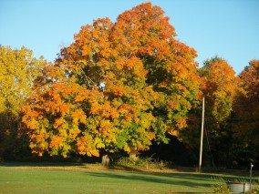 Figure 1: Vermont maple tree after a frost in fall.When leaves turn, forest transpiration is over for season.
 Figure 2: Dry summer weather.If the soil dries down, evaporation falls and it gets warmer
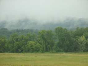 Figure 3: Rain evaporating off the forestFast evaporation of rainoff forest gives low cloud-base.
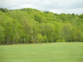 Figure 4: Vermont forest in springCooler cloudier days after leafout
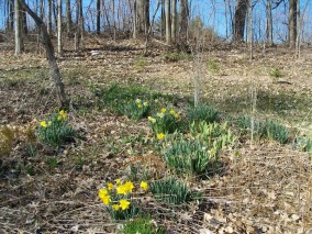 Figure 5: Warm dry sunny day before leaf-outDaffodils in early spring on a warm dry sunny day before leaf-out in Pittsford, Vermont
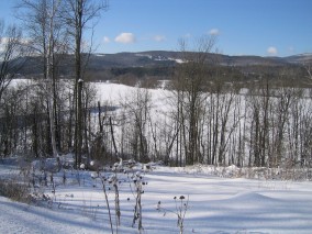 Figure 6: Winter snow in VermontSnow reflects sunlight except where shaded by trees


